Background
The Republic of Seychelles is an archipelago of 115 islands within a rich tropical marine ecosystem in the Western Indian Ocean. Seychelles is a ‘large ocean state’ with an Exclusive Economic Zone (EEZ) of 1.35 million km2. The islands have high rates of species endemism and Seychelles’ ocean contains many species and different habitats from tiny corals polyps to huge seamounts and underwater canyons. Marine tourism, fisheries and all aspects of the Blue Economy are vitally important. The Seychelles Marine Spatial Plan (SMSP) Initiative began in February 2014 and builds upon existing marine protection and planning efforts in Seychelles. The SMSP has three main objectives: expand marine protection to 30% of the EEZ, address climate change adaptation and support the Blue Economy in the entire 1.35 million km2 of Seychelles’ ocean. Seychelles’ Blue Economy is integral to national sustainable development goals and integrates climate change and ocean protection targets. The SMSP has contributed to Seychelles’ updated Nationally Determined Contributions (NDC) of July 2021 with the SMSP initiative’s efforts to compile seagrass mapping from 2014-2018 and using species representation goals for the 30% marine protection areas including seagrass and mangrove. In 2017, a Specific, Measurable, Achievable, Relevant and Timebound (SMART) objective for climate change was approved for the SMSP: develop climate change risk mapping for coral reefs in Seychelles.
The purpose of the project was to analyse 10+ year time series datasets that represent ocean condition variables that could be relevant to defining the risk to habitats from climate change. One of the concerns for coral ecosystems in Seychelles – and throughout the Western Indian Ocean – is mass bleaching events. Improving the understanding of climate change impacts would inform zoning design proposals and integrate concepts of climate change resilience to the SMSP.
This was not a comprehensive analysis and in many ways was a pilot to test the integration of climate-smart methodology with existing MSP databases at a time when climate was still a new objective for MSP globally. Could we identify areas with different patterns of thermal stress over time and at a scale relevant to the MSP zoning designs? In other words, using remote sensing data, identify areas with many anomalous (i.e., very warm) Sea Surface Temperature (SST) months to indicate potentially thermally impacted areas; conversely areas with few anomalous SST months might represent thermal refugia for corals.
Methods
The SMSP is a government-led process, with planning and science support from The Nature Conservancy, and uses a participatory, integrated, and multi-sector approach to support the health and sustainable long-term use of the Seychelles’ ocean waters. More than 11 major sectors including civil society organisations (CSOs) participated in the SMSP including fishing, tourism, marine charters, biodiversity conservation, renewable and non-renewable energy, port authority and maritime safety. The Seychelles MSP uses an integrated Planning Unit approach with two grid sizes of 1 km2 and 50 km2 for shallow (<200m) and deep waters (>200m), respectively. The nearly 100 data layers compiled by the MSP team and other local planning projects were integrated with these Planning Units, providing a flexible and adaptive approach to focus analyses on specific features or geographies.
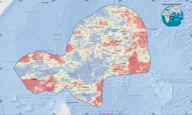
The primary analysis in this project was a high-resolution data visualization for Sea Surface Temperatures (SST) to measure trends across the EEZ through time and achieve a better understanding of patterns across space. This analysis used the number of heat stress months as defined by +1C above the long-term average. A secondary analysis was done using ESRI’s 3-dimensional time-space data structure, called the Space Time Cube, an ‘Emerging Hotspot Analysis’ toolset to enable location specific trends in time associated with various ocean conditions. Remotely sensed SST data were used from multiple satellite data products available to the public at varying spatial and temporal scales. The global data sets were from the Multi-scale Ultra-High Resolution (MUR) SST analysis anomaly at approx. 1 km spatial resolution from 2002-2019 for the ‘heat stress months’ and 2008-2019 for the Space Time Cube: both in monthly composites.
Results
The visualization of the data and mapping over the EEZ revealed several areas with the highest number of months with anomalously high average SST. These areas were over Fortune Bank and eastward to the EEZ boundary, the northwest section of the EEZ boundary including and west of the Coco de Mer seamount ridge, and the southern waters inclusive of the Farquhar Archipelago. The database also showed areas with no months with anomalously high average SST. These potential thermal refugia included the southern end of the Amirantes Plateau, Aldabra Group (Aldabra, Assumption, Cosmoledo, Astove) and deep waters in central and western areas of the EEZ. These data and maps were used to inform proposals for high biodiversity protection zones and provided useful information with decisions in key areas such as the Amirantes Basin where tradeoffs were discussed with stakeholders for balancing ecological and economic objectives. The integration with the MSP Planning Units also meant it was possible to quickly subset the SST data to focus on discussion areas.
In March 2020, the government of Seychelles legally designated more than 410,000 km² as Marine Protection Areas after more than 250 workshops and meetings with more than 150 stakeholders. Five ‘High Biodiversity Protection’ Areas cover 203,235 square km and eight ‘Medium Biodiversity Protection and Sustainable Use’ Areas cover 217,589 square km. The 13 new marine protection areas are home to endangered species and economically vital fish stocks and include climate change refugia as well as important foraging areas. The 30% protection by area and representation includes 84% of total seagrass and 85% of total coral reefs.
Conclusion
- Developing a climate smart MSP relies on multiple data sets, some of which are available globally from remotely sensed sources.
- These large datasets require substantial computing power to manage, analyse and visualize in GIS, which is an important consideration for any MSP process.
- Climate smart MSP is growing and, in particular, to look at resilience in a planning context for both biodiversity protection values and socio-economic values and livelihoods.